Home  /  Location

Zone 4, Jinnah Avenue — closer than most people expect

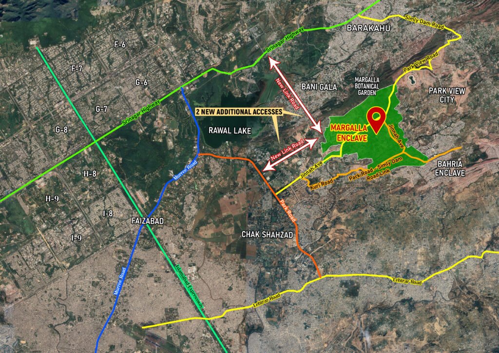
Minutes from Park Road, well inside the Islamabad Capital Territory, with direct access planned to the Srinagar Highway.

How to reach us

DHA Margalla Enclave — location & access roads

Positioned off Jinnah Avenue near Bani Gala and Rawal Lake, with two new link roads planned to connect directly to Srinagar Highway and Park Road.

Action needed: this image is a placeholder. Click it in Elementor → click the image again in the panel → Upload/select your real map JPG from your Media Library. Once swapped, your exact original map displays here, full quality, with the animation and styling already applied — no further edits needed.

Site layout

How the sectors sit on the ground

A simplified diagram of how ME-1 through ME-4 and the Lake District relate to the main boulevard and entrance — built as a vector graphic so it stays sharp on any screen size, unlike a scanned or photographed site plan.

MARGALLA HILLS MAIN BOULEVARD Main Entrance — Jinnah Avenue ME-1 5 & 10 Marla + Commercial Main boulevard frontage ME-4 5 & 10 Marla Mirrors ME-1 ME-2 / ME-3 1 Kanal Residential Elevated sections, Margalla Hills views ME-1 / ME-4 — Residential + Commercial

Note for site builder: this is a schematic layout illustrating relative sector positions — it is not to scale and is not a substitute for DHA’s official surveyed site plan. Replace with the real master plan drawing once available, or update sector shapes/positions here to match it.

What's nearby

Landmarks within easy reach

PIMS Hospital

~9 km

Parliament House

~12 km

Blue Area

~11 km

Serena Hotel

~11 km

Park Road

~3 km

Zero Point

~10 km

Islamabad Airport

~35 km

Margalla Hills Trails

~5 km

Master plan detail

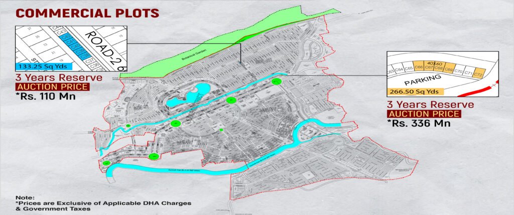
Commercial plots & sector layout

Commercial plots line the boulevard around the Lake District. Sectors ME-II, ME-III, ME-IV, and ME-V surround the lake and Gumrah Kas waterway.

Action needed: this image is a placeholder. Click it in Elementor → click the image again in the panel → Upload/select your real map JPG from your Media Library. Once swapped, your exact original map displays here, full quality, with the animation and styling already applied — no further edits needed.
Connectivity

Getting to and from the site

Jinnah Avenue frontage

Direct access from one of Islamabad’s main arterial roads.

Srinagar Highway link (planned)

A future direct connection is planned, reducing travel time to the wider ICT.

Close to Zone 4 amenities

Sits within Zone 4, alongside other established DHA and CDA sectors.

Margalla Hills backdrop

Northern boundary runs along the base of the Margalla range.

Want to visit the site in person?

We arrange site visits on request, including remote video walkthroughs for overseas buyers.